King County Geographies
Data on Communities Count are most commonly reported for King County as a whole, for 4 regions within the county, and by cities and neighborhoods (formerly known as Health Reporting Areas). Education data are reported by school district. Whenever possible we provide data at the city/neighborhood level, but sometimes information for geographic areas smaller than the county or region cannot be displayed due to issues of a small sample size, data reliability, or to protect individual identities.
Please see below for more information about our King County Regions and Cities and Neighborhoods. You may also contact us at CommunitiesCount@kingcounty.gov with questions about our geographies.
Regions
Click the image to view a larger, searchable map. Entering an address in the map search bar will show which region an address is located in.
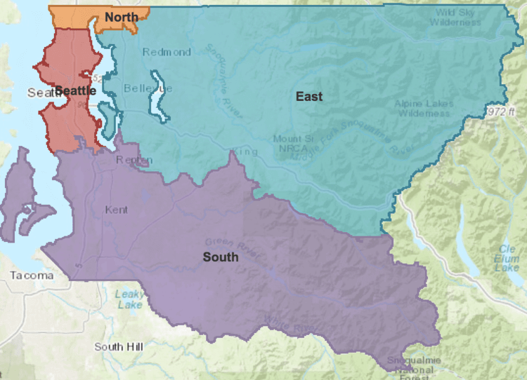
Regions: Whenever possible, indicators are reported for King County overall and for 4 Regions (North, East, Seattle, and South) within the county. Unless otherwise noted in the Notes & Sources section for the indicator, region boundaries are based on aggregated cities and neighborhoods and census block groups.
North Region includes the areas of Bothell, Cottage Lake, Kenmore, Lake Forest Park, Shoreline, and Woodinville.
East Region includes Bear Creek, Bellevue, Carnation, Duvall, Issaquah, Kirkland, Medina, Mercer Island, Newcastle, North Bend, Redmond, Sammamish, Skykomish, and Snoqualmie.
South Region contains Algona, Auburn, Black Diamond, Burien, Covington, Des Moines, Enumclaw, Fairwood, Federal Way, Hobart, Kent, Lakeland, Maple Valley, Milton, Normandy Park, Pacific, Renton, Tukwila, SeaTac, Skyway, White Center, and Vashon Island.
Cities and Neighborhoods

Click the image to view a larger, searchable map. Entering an address in the map search bar will show which city/neighborhood an address is located in.
Cities and neighborhoods (Health Reporting Areas (HRAs)): City and neighborhood data are reported in a geography called Health Reporting Areas (HRAs), which were created to coincide with city boundaries in King County. Where possible, these 61 cities and neighborhoods correspond to neighborhood groupings within large cities, and delineate unincorporated areas of King County. In some cases, cities and unincorporated areas need to be grouped together to present data.